

Monitoring a Chance for Widespread, Moderate to Heavy Rain Next Wednesday and Thursday
SEPT. 25, 2026
Quiet weather and summer-like heat looks to continue through the weekend. However, significant changes to the weather pattern are forecast to take place the middle and latter parts of week that will bring increasing chances for rain and slightly cooler temperatures. Some significant totals of rain will be possible. Next week’s cold front is expected to be the start of a somewhat cooler/less hot pattern as we move through October. Long-range forecasts don’t call for any additional mid and upper 90-degree readings through the first half of October.
Friday’s weather maps showed a large area of high pressure, or heat dome, covering the south-central U.S. and northern Mexico. The heat dome is forecast to remain over Texas through the weekend but should begin sliding south and west into Mexico Sunday into Monday. At the surface, a weak cold front currently located along the Interstate 35 corridor and pushing slowly to the west. This front is expected to bring noticeably drier air to the region Friday through Saturday. The humid air will likely return to the area on Sunday. Mostly sunny and dry weather is forecast Friday afternoon through Monday.
- High temperatures Friday through Monday are forecast to be in the mid and upper 90s across the Hill Country and Central Texas regions. A couple of spots could easily reach 100 degrees on any of the days. Middle-90s are forecast for the coastal region
Changes in our weather are forecast to begin taking place next Tuesday into Wednesday when a West Coast trough of low pressure tracks east to the southern Plains. In advance of the trough, a southerly flow off the Gulf will increase, bringing deep moisture to much of the state. With the atmosphere becomes increasingly moist and unstable, scattered rain showers and thunderstorms are forecast to develop across the region Tuesday into Wednesday. The probability for rain will be near 40 percent Tuesday, increasing to 50 percent on Wednesday.
The most favorable period for rain showers and thunderstorms and potentially heavy rain is forecast to occur late Wednesday through Thursday. A Pacific cold front associated with the trough over the Plains is predicted to track across Texas Thursday and Thursday night. Widespread rain showers and thunderstorms are forecast to occur ahead of and along the front, with the possibility for some light rain lingering Thursday night into Friday morning.
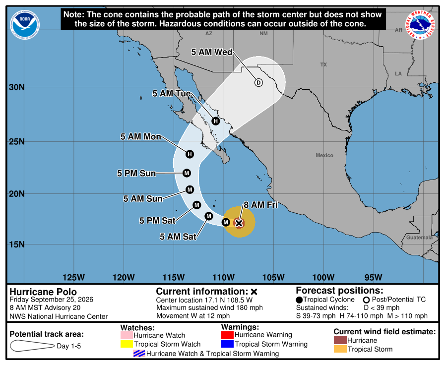
Next week’s rains across Texas will have the potential to be fairly heavy thanks to remnant moisture from major eastern Pacific Hurricane Polo. National Hurricane Center forecaster are calling for Polo to cross Baja, California and move inland over northwestern Mexico early next week, with the remnant center moving into Far West Texas next Wednesday. Clouds and moisture from the system will have the potential to get pulled east to the frontal boundary, possibly enhancing the chance for rain and thunderstorms across Central and South Texas.
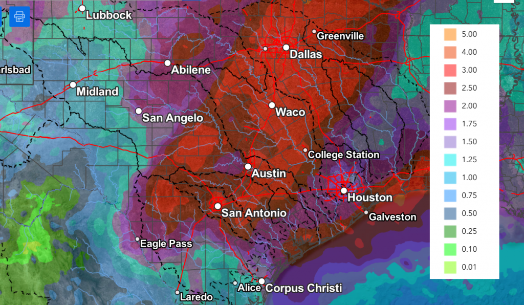
The National Weather Service’s rainfall forecast valid through next Friday morning calls for the highest totals of rain to occur across parts of West and Northwest Texas. Across the Hill Country, Central Texas, and the coastal region, totals of 2-3 inches are predicted. Keep in mind there is considerable uncertainty in this forecast due to the possible influence from Polo. Depending on how the situation evolves, totals could go much higher over parts of the region. Stay tuned for additional updates.
NWS Rainfall Forecast Valid through 7 pm Next Friday, 9/2:
Sunny and dry weather is forecast to develop late next Friday as the cold front pushes south into the Gulf, allowing drier and slightly cooler Pacific air to spread into the region. High temperatures next Tuesday and Wednesday are forecast to be around 90-92 degrees. High temperatures late next week and next weekend are predicted to fall to the upper 80s, with lows falling to around 70-72 degrees.
Tropical Weather Outlook
Weather conditions remain quiet across the Gulf and Caribbean Sea. Tropical cyclone development is not expected here over the next seven days.
- Out across the far eastern Atlantic Ocean, Tropical Storm Gonzalo developed Thursday. As of Friday morning, Gonzalo was located about 70 miles south of Sal, Cabo Verde. Maximum sustained winds were near 50 mph with higher gusts. Little change in strength is expected Friday A gradual weakening trend is forecast to begin Friday night and continue through the weekend. Gonzalo was moving to the north-northwest at 10 mph.
- Tropical Storm Fay is still hanging on over the eastern tropical Atlantic. As of late Friday morning, Fay was centered about 1045 miles west-southwest of the Azores, moving to the west at 3 mph. Top winds were near 60 mph. Some slight strengthening is possible over the next few hours. Gradual weakening, however, is expected through the weekend.
- Polo is an extremely powerful Category 5 Hurricane! As of 10 am Friday, Polo was centered off the west coast of Mexico, about 410 miles south-southeast of Cabo San Lucas, Mexico. Polo was moving toward the west near 12 mph, and this motion is expected to continue through Friday. A gradual turn to the northwest and north is forecast on Saturday and Sunday, followed by a northeastward motion on Monday. On the forecast track, Polo is expected to approach Baja California Sur early next week. Maximum sustained winds are near 180 mph with higher gusts. Polo is a category 5 hurricane on the Saffir-Simpson Hurricane Wind Scale. Fluctuations in intensity are possible today, but some weakening is expected over the weekend. Polo is forecast to approach Baja California Sur as a strong hurricane early next week.
The Best Harvest Moon in Five Years
There’s something special about this weekend’s full Moon. It’s a Harvest Moon and it will be closer to the autumnal equinox than any other full Moon of the past 5 years. The equinox gives the Harvest Moon a special power: It rises at sunset for several nights in a row. Most full Moons don’t do this.
Harvest Moons have special colors, too. Rising at dusk, they are bathed in twilight hues while the lunar disk is often amber and swollen by the Moon Illusion.
This year’s Harvest Moon occurring on Saturday Sept. 26th is extra Harvest-y. It’s closer to the equinox than usual: only 3.7 days later. Go outside at sunset this weekend, face east, and enjoy the Harvest Moonlight. (credit: Spaceweather.com)
Have a great weekend!
Bob
Legal Disclaimer:
EIN Presswire provides this news content "as is" without warranty of any kind. We do not accept any responsibility or liability for the accuracy, content, images, videos, licenses, completeness, legality, or reliability of the information contained in this article. If you have any complaints or copyright issues related to this article, kindly contact the author above.
